|
You are here: Spotlight Topics > Travel > Maps and Guides
Maps and Guides
Accurate maps and guides are now considered essential tools, but they were not always available to earlier travellers.
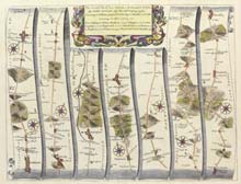
John Ogilby's 'Britannia' (1675) was the first real road atlas of Britain. It was quite different from modern road maps, being much too large and heavy to be used in travel.
Ogilby uses a series of strips to show the principal roads between different towns. He describes Nottingham as "a large and well-built town
formerly strengthened with a wall and castle, now ruinous".
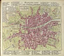
The representation of the city of Dublin in A. Dury's 'Collection of Plans' (1764) illustrates another guide for the traveller - the street plan, identifying principal buildings of interest.
Town plans were published from the early 17th century. They provide evidence of the early layout and development of urban communities, which can often still be detected in the routes through modern cities.
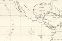
Midshipman George Ross Divett made a hand-drawn chart of the voyage of H.M.S. Sutlej from Vancouvers to Valparaiso. In other logs from 1863 to 1869 Divett recorded journeys in North and South American waters, the West Indies, and around Britain.
There are many other manuscript maps in the collections. The majority concern land use or property boundaries, rather than routes of transport or communication.
Further sources relating to this subject area are held by Manuscripts and Special Collections at King's Meadow Campus. See our website for information about our collections and catalogues.
|